In 2017, Karen Anderson, Associate Professor at the University of Exeter in England, made a trip to the Himalayas in Nepal with an aim to study the region’s glaciers. Like other visitors, she was fascinated by the soaring high mountains clad with white blankets of snow, but what ultimately caught her attention were the colored patches of vegetation, rarely seen at that altitude.
For Anderson, the changing landscape on these slopes pointed to the spread of vegetation where it hadn’t been before or at the least, not recently. It’s an important observation that will help determine the health of the water cycle for a region that is home to over 1.3 billion people. Research in other parts of the world has shown that expanding vegetation could have a great impact on the flows and stores of water. And in the Himalayas, the ecosystem is already in danger due to global warming.
“We wanted to see the spread of the vegetation across the Himalayas, and what it might mean for these people,” says Anderson. But surveying the landscape at 4000 meters, in terrain like that of the Himalayas, isn’t easy. “Once you go above 3000 meters, you start to feel quite sick. And every time you go higher you feel worse and worse. Working in these places is quite challenging.”
Anderson eventually went back to the UK — but she kept an eye on the Himalayas, using the assistance of NASA’s Landsat satellites.

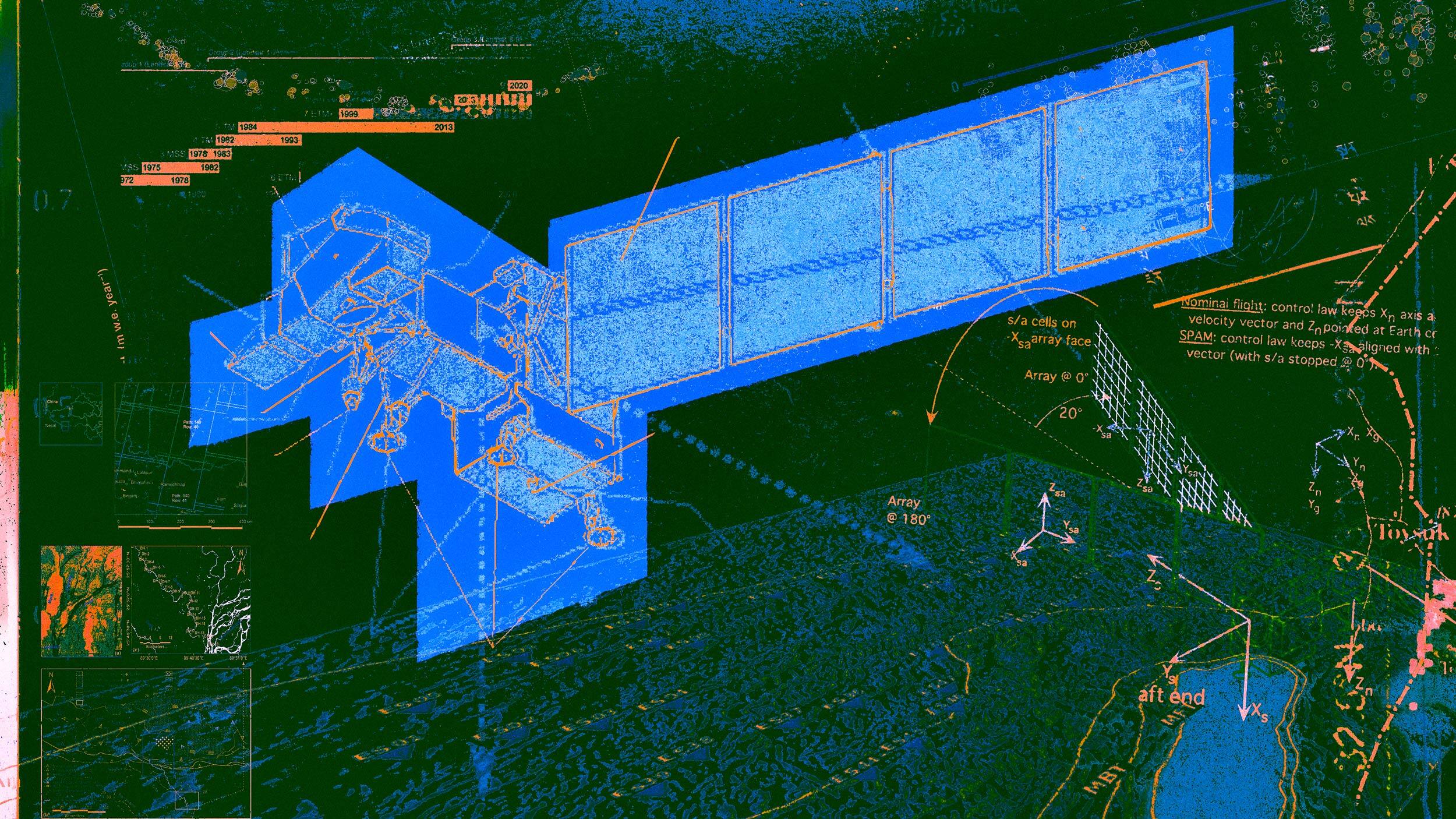
Landsat is a collection of satellites that gather data and images to observe the planet. It was first launched in 1972 and is one of the longest-running programs undertaken by NASA. Since its inception, more successors have been added to the program. The latest in the series, Landsat 9, was launched in September 2021, advancing and improving the previous versions. (Supercluster photographer Pauline Acalin was on-site to the mission.)
Landsat 9 was built to monitor the Earth’s land surface and "will be our new eyes in the sky when it comes to observing our changing planet,” said Thomas Zurbuchen, NASA's associate administrator for science. Landsat data allows scientists to track "agricultural productivity, forest extent and health, water quality, coral reef habitat health, and glacier dynamics," according to NASA.
Data and information on the Himalayas is particularly hard to access because of the rough terrain and geopolitical tensions. Known as the third pole of the world, the Himalayas are the largest reservoir of freshwater outside of the polar regions. But only 30 out of the more than 50,000 glaciers in the Himalayas and the Hindu Kush region are closely monitored.
“Satellites are incredibly helpful in allowing us to reach hard ecosystems. They provide a synoptic viewpoint of habitat, which allows us to reach places where we otherwise cannot,” says Anderson. She is not alone, other researchers like M.P.S Bisht, Director at Uttarakhand Space Application Center, India, agree. “Space technology is the only technology with which we can access points deep inside the Himalayan terrain.”

“No one can access these areas on foot.”
According to Bisht, technologies exist to study other remote regions like the Arctic and Antarctica. But it is far more difficult to study and monitor tough terrains like the Himalayas, or other mountainous glaciers, where landslides, high winds, earthquakes, and other natural disasters are common.
The third pole has already lost billions of tons of ice due to accelerated melting.
While Anderson’s study using satellite data revealed that the vegetation in the Himalayas is increasing, she mentions it cannot be ascertained that melting of glaciers and vegetation growth in the area is a direct consequence of global warming. “ There exist many other factors like land-use patterns, type of vegetation, etc. Certainty can come only with more data and in depth intersectional studies.”
Because of the high population density in the downstream region, the current dearth of information about these quickly melting glaciers is particularly worrying. Ten major Asian river basins depend on water from the Himalayas, some supporting hundreds of millions of people.
“Space science can make it possible” says Bisht.
In the last two decades, satellite images have helped many scientists to study the Himalayan region like never before. Scientists have been using satellites to determine the loss of glaciers in the region, to study the decline in the recharge of waters in the downstream rivers, to estimate decreasing groundwater levels, and to study rainfall patterns.
And with technologies like Landsat, researchers have been able to reveal and monitor disasters in the most remote parts of the interior mountains. For example, using satellite data, researchers revealed ten undocumented floods in the Himalayas in the last 30 years.
“With the use of satellite imagery from NASA’s Landsat series of satellites, experts are able to retrieve critical information to strengthen preventive measures against flooding, by filling our gaps in knowledge and understanding about glacial lake outburst floods,” says the UN. “With the help of this new analysis, which consisted of nearly 2,500 Landsat images of an area of approximately 10,000 square meters between 1988 and 2016, the known number of glacier-related floods was nearly doubled.”
With advancing Landsat technology Bisht can now access these inhospitable areas from a computer screen, with up to 2.5-meter resolution. But still, the data available around the Himalayas is quite limited. “What we need now is to study the Himalayas further, so we can build resilience towards these disasters,” adds Bisht. “Right now, we are more reactive to disasters. What we need is to be proactive.” More studies using these satellite data is a step in the right direction.
Last year, the United Nations Intergovernmental Panel on Climate Change published an assessment that showed a large decrease in snow-covered areas in most of the Hindu Kush Himalayan region. Data also shows snow volumes will decrease across the board with glacier volumes also declining.
“Look at Japan, they had frequent tremors so they thought of measures to mitigate damage. Singapore fought off water scarcity with new technology,” Bisht explained to the Times of India. “We need similar interventions to battle climate change because climatological cycles are inevitable.”